

Mountaineering sport club „Čelik“ from Smederevo created and marked the local hiking trails with starting point on the Danube quay. Hiking enthusiasts can choose one of 6 hiking trails from 5 to 22 km long. Along Golden Hill (Mons Aureus) trail, you can see the most beautiful view of the Danube and Banat plains.
HIKING TRAIL 1 – “ĆIR ANTINA ČESMA“ – 5 KM
This trail starts at the Silos in the Danube park. It goes upstream along the Danube to the outdoor basketball courts, over the street behind Monopol building, along the Danube Street through Provalija all the way to gravelled Petra Dragojevića Street.
After crossing the footpath through the forest to Vladimir Nazora Street towards the big asphalt junction, turn left to the small path and then to the footpath from where you can see Ćir Antina fountain. Alternating narrow path and the path through the forest lead to the pebbled road coming out to Gorička Street, along Gorička Street to Narodnog Fronta Street and you will get back to the starting point, Danube quay.
HIKING TRAIL 2 – „THE OBRENOVIĆ VILLA” – 7.5 km
It continues to the hiking trail 1 a little distance away from Ćir Antin fountain and then on the intersection of the forest road, go right to the footpath along the vineyard which comes out on Tuzlanska Street. Then, turn right to Timočka Street which leads to the gate of Villa Obrenović.
Hike back along the pebbled road above the estate of Obrenović Villa, down Gročanska and Nevesinjska Street to Gorička Street. Then along Gorička and Narodnog Fronta Street you will get to the starting point, the Danube quay.
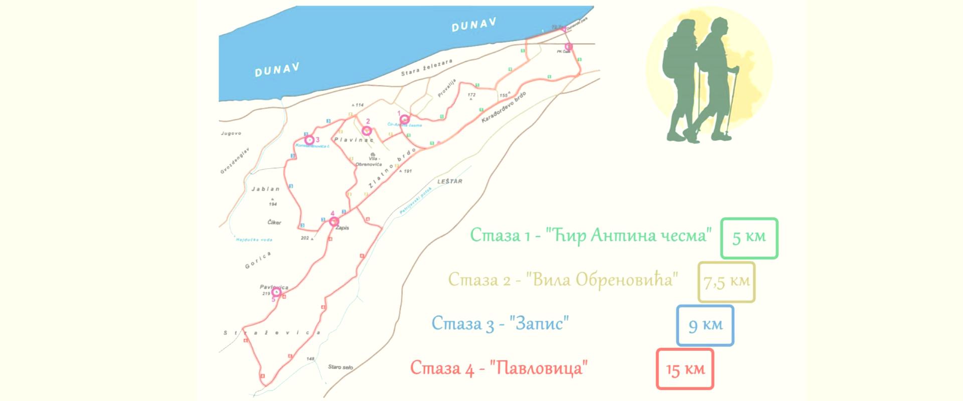
HIKING TRAIL 3 – „ZAPIS “ – 9 km
Note: Zapis is a place where an oak tree was located in the past and this oak tree was designated as Zapis (old oaktree with the cross engraved). The place is arranged and marked. There is no oak tree but there is a cross made out of this tree. You will find benches for rest around.
The same as trail 2 to the Obrenović Villa then down to the asphalt of Bratstva i Jedinstva Street, then Vojvođanska, followed by Prizrenska and Gročanska Street. The station is in Prizrenska Street, Konstatinović drinking Fountain.
From the fountain continue along Prizrenska Street, enter Gročanska Street, then you will see the roads outside the settlement which leads to Zapis in Gorička Street.
From Zapis along Gorička and Narodnog Fronta Street you will get to the Danube quay.
HIKING TRAIL 4 – „PAVLOVICA “ – 16 km
This is the longest hiking trail. The first part of the hiking trail is the same as for hiking trail 3 to Zapis. Then along the pebbled road you climb to the highest point of Smederevo – trigonometric point, pyramid Pavlovica 219 masl.
After pyramids, it continues to pebbled road leading to Petrijevo, then after about 600 m turn left onto the Petrijevski stream and after about 800 m to the left through the ways on the left side of the stream and get to Fočanska Street.
After a 2-kilometre hike, go uphill to Gorička 400 m after Zapis. Along Gorička and Narodnog fronta Street, you will get to the Danube quay. Option 2 is to return from Pavlovica the same way to Zapis and continue along Gorička Street.
HIKING TRAIL 5 – „MILITARY HOSPITAL“ – 22 km
It continues to the hiking trail 4 from Pavlovica. It stretches to the village of Vodanj and then to the military (partisan) hospital.
HIKING TRAIL 6 – „GVOZDENGLAV “ – 20 km
It continues to the hiking trail 4 from Pavlovica. About 2 km from Pavlovica in the direction towards Udovički road, there is one nice viewpoint – Gvozdenglav.
It is the former trigonometric point where there was a construction – pyramid similar to the one on Pavlovica, but now there is a stone pillar which serves for surveying the terrain.
The altitude varies when climbing to Gorička Street from 200 to 300 m, increasing all the way along the hiking trail.
Some more information about local hiking tours can be found on the website of PSK „Čelik“ or by calling +381 60 3128 993 or writing to info@pskcelik.rs